A three-storey medical centre project on the northern side of the Murrumbidgee River floodplain prompted one of the more instructive MASW surveys we have run in Wagga Wagga. The boreholes showed interbedded sands and stiff silty clays to about 15 metres, but the client’s structural engineer needed a VS30 value to lock in the seismic site class under AS 1170.4 before finalising the lateral load model. We deployed a 48-channel linear array with 4.5 Hz geophones across two orthogonal spreads, capturing both active-source and passive microtremor data from vehicle traffic along the Sturt Highway corridor. The inversion produced a clear impedance contrast at 28 metres, giving a VS30 of 295 m/s, which placed the site firmly in Class C. For deeper basin characterisation east of the CBD, the seismic refraction method can map bedrock topography where the alluvial cover exceeds 30 metres, though in Wagga Wagga’s central business district the shear-wave velocity profile often controls the foundation design conversation directly.
MASW in Wagga Wagga must resolve both the floodplain soft-soil amplification and the impedance contrast at the weathered bedrock interface, typically between 25 and 45 metres depth.
Technical details of the service in Wagga Wagga
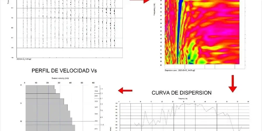
Field demonstration
Critical ground factors in Wagga Wagga
Wagga Wagga’s expansion from a river-crossing settlement into the largest inland city in the Riverina has pushed development onto increasingly varied ground, from the Quaternary alluvium of the floodplain to the Ordovician metasediments of the Wagga Wagga Anticlinorial Zone. The seismic risk conversation here is not about proximity to plate boundaries but about basin-edge effects and impedance contrasts within the soil column. A site classified as Class C on VS30 alone can still exhibit spectral amplification at periods of 0.2–0.5 seconds if a low-velocity clay layer sits between stiffer strata, a scenario we have documented in several investigations near the railway corridor. The National Construction Code references AS 1170.4 for earthquake actions, and an incorrectly assigned site class can shift the design response spectrum by one full sub-class, increasing the seismic base shear by 20–40 percent. MASW surveys that stop at 30 metres without resolving the deeper velocity structure can miss a critical low-velocity zone that controls the fundamental site period, leaving the structural model unconservative.
Our services
The MASW survey is rarely a stand-alone dataset in Wagga Wagga. We typically pair it with intrusive testing to ground-truth the velocity model and provide the full suite of geotechnical parameters the structural team needs for foundation design and liquefaction screening.
Combined active and passive MASW
Full-dispersion acquisition using sledgehammer source for high-frequency data above 8 Hz and ambient-noise recording for low-frequency Rayleigh-wave energy, processed with the spatial autocorrelation (SPAC) method to extend the Vs profile to 60–80 metres depth.
VS30 site classification reports
Site class determination per AS 1170.4 Table 4.1, including time-averaged shear-wave velocity to 30 metres, fundamental site period from H/V spectral ratio, and commentary on any low-velocity interlayers that may warrant site-specific response analysis.
Cross-hole and down-hole seismic verification
Borehole-based shear-wave velocity measurement used to calibrate MASW dispersion curves where complex stratigraphy produces non-unique inversions, particularly in the transition zone between alluvial and residual soils.
Liquefaction screening with Vs data
Shear-wave velocity-based liquefaction triggering analysis following the Andrus and Stokoe (2000) framework, integrated with SPT data to assess cyclic resistance ratio in the saturated sandy layers common beneath the Murrumbidgee floodplain.
Top questions
What does a MASW test in Wagga Wagga cost?
MASW surveys in Wagga Wagga typically range from AU$2,250 to AU$4,710 depending on array length, number of spreads, and whether passive microtremor recording is required. A single 48-channel active-source spread with processing starts near the lower end; adding a passive array for deeper profiling or a second orthogonal spread for 2D coverage moves toward the upper range. We provide a fixed-quote proposal once we review the site location and depth of investigation needed.
How deep can MASW investigate in the Riverina soil conditions?
With a 72-metre active-source spread and passive microtremor recording, we routinely resolve Vs profiles to 60–80 metres in Wagga Wagga’s alluvial and residual soil settings. The maximum depth is controlled by the longest resolvable Rayleigh-wave wavelength, which depends on array aperture and the stiffness of the deepest layer. In the Wagga Wagga Anticlinorial Zone where bedrock is shallower, the investigation depth is naturally limited by the high-velocity contrast at the rockhead.
How long does a MASW survey take on site?
A single 48-channel active-source MASW spread with multiple shot points takes approximately 1.5 to 2 hours for setup, acquisition, and quality control. Adding passive microtremor recording extends site time by 30–45 minutes. A full survey with two orthogonal spreads and passive arrays across both is typically completed within a half-day on site, with processing and inversion completed in the laboratory over the following two working days.
Is MASW accepted for AS 1170.4 site classification?
Yes, MASW-derived VS30 is accepted under AS 1170.4-2007 for site classification, provided the survey methodology and inversion process are documented in the geotechnical report. The standard specifies time-averaged shear-wave velocity over the top 30 metres as the primary classification parameter. Our reports include the full dispersion curve, inversion model, and VS30 calculation so the structural engineer can verify the assigned site class.
Do you need boreholes alongside MASW in Wagga Wagga?
We strongly recommend at least one borehole or test pit to ground-truth the stratigraphy, especially in Wagga Wagga where the alluvial sequence can include thin gravel lenses or cemented layers that affect the inversion. When the velocity profile shows a smooth gradational increase with depth, the inversion is generally well-constrained without borehole data. However, where the dispersion image suggests sharp impedance contrasts, a borehole log helps resolve the non-uniqueness inherent in surface-wave inversion and confirms the geological interpretation.