In Wagga Wagga, the design and analysis of slopes and retaining structures are critical components of geotechnical engineering, ensuring the stability of both natural and man-made landforms. This category encompasses the assessment of ground conditions, the design of support systems, and the implementation of stabilization measures to manage earth pressures and prevent ground movement. Given the region's rolling topography and proximity to the Murrumbidgee River, effective slope management is essential for protecting infrastructure, enabling safe development, and mitigating risks associated with erosion and landslides.
The local geology presents specific challenges that demand rigorous geotechnical input. Much of Wagga Wagga is underlain by the Wagga Wagga Granite, often deeply weathered to form silty sands and clays, which can be highly erodible and prone to instability when wet. Alluvial deposits along the river flats add further complexity, with soft, compressible soils that can complicate foundation and retention systems. Reactive clay soils are also common, subject to significant shrink-swell movements with seasonal moisture changes, directly impacting the performance of retaining walls and cut batters.
All assessments and designs must align with Australian Standards, primarily AS 4678-2002 for earth-retaining structures and AS 5100.3 for bridge and associated retaining wall design. The design philosophy is typically based on limit state principles, considering both ultimate and serviceability conditions. Local council requirements from the Wagga Wagga City Council Development Control Plan and engineering guidelines also dictate specific parameters for drainage, aesthetics, and long-term durability, ensuring structures are robust yet integrate appropriately with the surrounding environment.
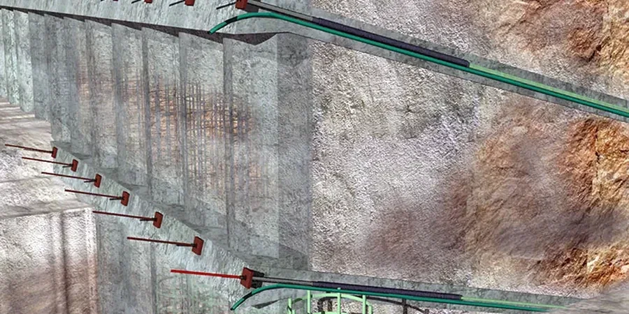
Typical projects requiring these specialist activities range from residential subdivisions on sloping blocks, which often need engineered retaining wall design to create usable platforms, to large-scale civil infrastructure. Road widening and bridge approach embankments frequently demand complex slope stability analysis to ensure safe angles and prevent failures. For deep excavations or where space is constrained, an active/passive anchor design provides a high-capacity solution to retain soil without bulky internal structures, securing walls against overturning and sliding.
Questions and answers
What are the key signs that a slope or retaining wall on my Wagga Wagga property might be failing?
Common indicators include new or widening cracks in the wall or adjacent ground, tilting or bulging of the wall face, water seepage through or around the structure, and soil erosion at the base. For slopes, look for tension cracks near the crest, slumping, or leaning trees. If you notice these, a professional geotechnical assessment is crucial to prevent a sudden collapse.
How do the reactive clay soils common in Wagga Wagga affect retaining wall design?
Reactive clays exert significant swell pressures when wet and shrink during dry periods, creating large lateral earth loads and cyclic movement that can crack rigid walls. Design must account for these pressures through robust reinforcement, flexible jointing, and comprehensive drainage to control moisture content behind the wall, preventing water build-up that triggers swelling.
What is the difference between a gravity retaining wall and a cantilevered retaining wall?
A gravity wall relies on its own massive weight to resist sliding and overturning, typically built from stone, concrete, or gabion baskets. A cantilevered wall uses a reinforced concrete stem on a base slab, with the backfill's weight on the slab heel providing stability. Cantilevered walls are more material-efficient for greater heights, whereas gravity walls are simpler for lower applications.
Do I need council approval and a geotechnical report to build a retaining wall in Wagga Wagga?
Yes, most retaining walls over a certain height, typically one metre, require development consent from Wagga Wagga City Council. A geotechnical investigation report, including site soil classification and design parameters, is usually mandatory to support the structural engineering plans and demonstrate compliance with AS 4678 and local controls for safety and drainage.