A residential development on the northern slopes of Wagga Wagga, overlooking the Murrumbidgee River, can quickly turn complex when a 3-metre cut exposes a mix of residual granite and saturated alluvium. This is where standard designs fail and geotechnically-informed retaining wall engineering becomes essential. The team at our NATA-accredited facility, operating to ISO 17025 standards, approaches each Wagga Wagga project by first understanding the site’s specific soil profile—often the weathered Kyeamba Granodiorite overlain by silty loams. A test pit investigation provides the first real look at the subsurface layers, allowing the engineer to identify the boundary between colluvial deposits and the underlying bedrock before a single calculation is made.
A retaining wall in the Riverina isn’t just a structural element—it’s a groundwater management system disguised as a concrete face.
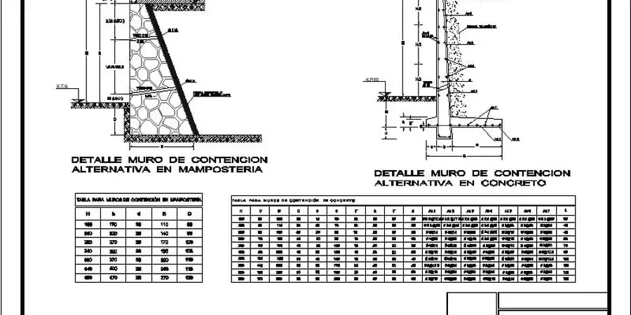
Technical details of the service in Wagga Wagga
Field demonstration
Critical ground factors in Wagga Wagga
A common error on Wagga Wagga building sites is treating the retaining wall as an isolated element, neglecting the influence of the backyard pool or the neighbour’s driveway surcharge just two metres behind the crest. That oversight leads to progressive tilting and cracking within the first two wet seasons. Another critical failure mode emerges when designers ignore the dispersive nature of certain local clayey silts; these soils can pipe internally through a poorly graded drainage blanket, clogging the weep holes and building hydrostatic pressure against the stem. The result is a wall that overturns slowly, often after the defect liability period has expired. A thorough study of the soil-structure interaction, including the assessment of passive resistance at the toe within the Murrumbidgee floodplain deposits, is the only reliable way to prevent these costly, long-term failures.
Our services
Our retaining wall engineering services in Wagga Wagga cover the full project lifecycle, from initial feasibility through to construction-phase support:
Gravity and Cantilever Wall Design
Reinforced concrete and masonry wall sections optimised for the moderate soil bearing pressures typical of Wagga’s granitic saprolite, balancing stem thickness against steel reinforcement ratios.
Reinforced Soil and Segmental Block Walls
Geogrid-reinforced solutions analysed with internal and external stability checks, ideal for tiered residential lots where total retained height exceeds 4 metres.
Anchored and Soldier Pile Systems
Design for deep basement excavations in the CBD’s denser alluvial terraces, integrating ground anchor capacity verification with tendon bond length calculations in weathered rock.
Drainage and Waterproofing Plans
Custom subsoil drainage layouts that prevent hydrostatic buildup behind the wall, specifying filter fabric grades and aggregate gradations compatible with the site’s silt content.
Top questions
What is the typical cost for a retaining wall design in Wagga Wagga?
The engineering design fee for a residential retaining wall in Wagga Wagga typically falls between AU$1,670 and AU$6,070, depending on the wall’s height, the complexity of the soil profile, and whether global slope stability analysis is required. This covers the geotechnical report, structural calculations, and stamped engineering drawings ready for council submission.
Does Wagga Wagga City Council require an engineer’s design for a retaining wall?
Yes. Under the National Construction Code and local development control plans, any retaining structure over 1.0 metre in height generally requires a certified design from a chartered professional engineer, along with site-specific soil test results. Walls under 1.0 metre may still need certification if they support a surcharge like a driveway or dwelling.
How do you account for the reactive clay soils found around Wagga Wagga?
We conduct laboratory Atterberg limits testing to quantify the soil’s shrink-swell potential. The design then incorporates a moisture-stable backfill zone behind the wall and a flexible drainage system that prevents the native reactive clay from exerting swelling pressures against the structure during prolonged wet periods following drought.
What information do you need to start the design process?
We start with a contour survey of the site, the proposed wall location and height, and the results of a subsurface investigation—typically a borehole or test pit with laboratory classification. If the wall is near a property boundary or easement, the land title and any existing service plans are also essential for a compliant design.